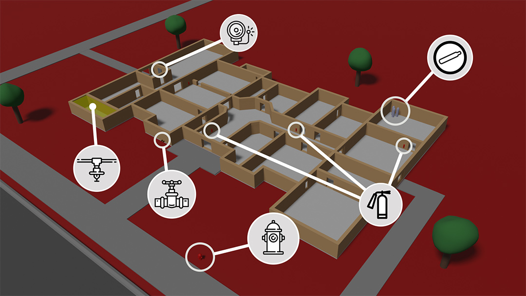
Hibou Systems MPX1
Pre-Incident Mapping Tablet

The Hibou Systems MPX1 aims to improve emergency spatial awareness to unaquainted environments to maximize response safety and efficiency. The MPX1 is able to create a digital map of any location, enable waypoints, and acts as a computing hub for our localization systems. Bring up previously mapped locations en route to an emergency to gather critical information to optimize your response.

  • 3D Mapping
  • 24h+ Battery Life
  • Mobile Command Tablet
  • Waypoint Generator
  • Simple User Interface
  • Digital Map Database
  • Training Scenario Generator
  • Automate Reporting Procedures


Hibou Systems MPX1 Pre-Incident Solution

Incentive

Provide residents and business owners with incentives on reduced insurance for conducting pre-incident evaluations.

Map

A prevention member easily creates a digital map of the environment and assigns the necessary waypoints to the map.

Train

Emergency services can use authoirzed maps as mock traning scenarios. Automatically generate a simulated emergency to work through with your team.

Respond

If an emergency occurs in a previously mapped environment, responders can bring up the digital map for an optimal and efficient response strategy.

Mapping

Creating Digital Blueprints

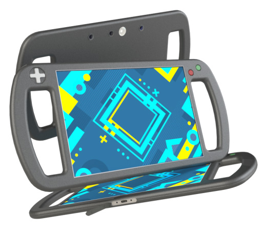
The MPX1 isn't just an ordinary tablet. It is instrumented with an array of specialized sensors to construct 3D maps with ease. Simply grab the tablet, point it in any direction and then move around the environment while watching the digital map generate in real time. When you are satisfied with the map, save it and the associated address for easy look-up later.

Waypoints

Information at your fingertips

Waypoints are digital references to useful information regarding emergency response. They consist of elements such as standpipe connections, fire barriers, hazardous material spaces, sprinkler rooms, and much more. When composing the digital map of the new environment, simply point the tablet at your desired waypoints and select the waypoint category. The waypoints are saved with the digital map and can be adjusted at any time off-site. If you are called to an incident at a mapped location, simply reference the location in our easy-to-use database to bring up the 3D map and all associated waypoints. Move the circle on the image below for an example use case for Fire or Police applications.
Original Image Fire
Police

Training

Maximizing Insight from Training

"Practice does not make perfect. Perfect practice makes perfect." - Vince Lombardi. Hibou System's MPX1 provides a new angle to mock scenario training by generating simulated emergencies in previously mapped establishments. This enables the response teams to not only prepare for an emergency, but also gain familiarity with real buildings in their community.

Response

the devil is in the details

There are no two identical emergencies. The key to an efficient response is directly related to the amount of information you have at your disposal as the action plan is formulated. The MPX1 aims to provide responders with the details needed to allocate their resources safely and effectively.

Frequently Asked Questions

We live in a world driven by information. When buying a car, we want to get all of the details of the internal and external specifications of the car before making an informed decision. The same goes for emergency response. By providing emergency responders with the critical spatial information en route to an emergency, they are able to optimize their response and maximize the probability for the preservation of life.
Yes. Once the maps are generated, waypoints and other adjustments can be made off-site and at any time. Backups are conducted periodically so that maps are not lost or accidently modified.